|
|
 |
| SW Aviator Magazine is available in print free at FBOs and aviation-related businesses throughout the Southwest or by subscription. |

|
 |

|
 |
 |
 |
|
The web's most comprehensive database of Southwest area aviation events.
|

|
 |

|
 |
|
Featured Site:
|
|
|
 |
|
A continuosly changing collection of links to our favorite aviation related web sites.
|

|
 |

|
 |

|
 |
Search by:

|
|
|
Or enter a keword:

|
|
|
Post a FREE Classified Ad 
|
 |
|

|
Rediscovering the Magic of Route 66
|
|
At the Grand Canyon Caverns
|

Story and Photos by Mark Swint
In the summer of ’69, fresh out of high school and college-bound, I had the unique opportunity of driving my blue Fiat 850 Spider — complete with white racing strip — across the country from Southern California to Ft. Lauderdale, Florida. It was a great adventure, and a great introduction to the vastness of this wonderful country. The first half of my journey was on the most famous highway in the world, Route 66.
At 2,448 miles long, Route 66 was the principle way to get from Chicago to Los Angeles, and opened the wonders of the American West to automobile travel in the process. Steinbeck called it “the Mother Road,” and Route 66 is the only road to have its own hit TV show and a number one smash hit on the top forty.
In those days, Interstates and mini-marts were just a dream, and you still had to slow down through every one-horse town and hamlet along the way. Each little community had their own way of enhancing the town’s revenue from the pockets of passing motorists: perhaps through the sheriff’s cleverly located speed trap, or, more often, through a steady supply of local attractions to entertain you — for a fee.
From snake farms to spider ranches to alligator and reptile farms, with a mix of “World’s Largest This” to World’s Smallest That” thrown in for good measure, every conceivable means of extracting a few bucks from the passing traveler was offered. I could visit the Dinosaur Pits and see the Dioramas, or pan for a gold nugget at a Real Working Gold Mine. Mixed in with this oleo were fresh produce and fruit stands hawking boiled peanuts (I love them now!), watermelons, fresh corn, and many other seasonal offerings for pennies a pound, plus the ubiquitous roadside diners and an eclectic mix of motels.
Now, with the advent of today’s eight-lane, no-stops superhighways, many of these small town attractions have all but dried up as the Interstates pass them by. However, traces of Route 66 are still out there for those able and willing to leave the Interstate. Many of the sideshows and most of the perils are gone now, but the desert is just as beautiful, and the spirit of Route 66 lives on in the hearts and souls of those hardy few who hang on to the memory and nostalgia of what once was. Some attractions remain and, by golly, they can be down right interesting.
 For those of us who fly, rediscovering the magic of Route 66 is hardly a detour at all. Approximately 100 nm southeast of Las Vegas, just beyond the Peach Springs VOR, is a little spot along what is now called Historic Route 66 named Grand Canyon Caverns. This attraction from the past is still going strong, and even has its own open red circle on the Phoenix Sectional chart enticing nostalgic aviators to drop in and spend some cash. For those of us who fly, rediscovering the magic of Route 66 is hardly a detour at all. Approximately 100 nm southeast of Las Vegas, just beyond the Peach Springs VOR, is a little spot along what is now called Historic Route 66 named Grand Canyon Caverns. This attraction from the past is still going strong, and even has its own open red circle on the Phoenix Sectional chart enticing nostalgic aviators to drop in and spend some cash.
Recently, I jumped in the 185 (way faster than the Fiat, but, sadly, not equipped with racing stripes) and visited Grand Canyon Caverns. On arrival, I found a nicely graded 5100-foot long dirt runway ready for any type of airplane willing to give it a go. Once on the ground, a long service road doubles as a taxiway, letting me taxi the plane right to the motel and mini-mart parking lot. I must admit, it’s kind of fun getting to park your plane right off the highway, where passing motorists can gawk, and kids can wish they could fly instead of having to sit in the stupid back seat of their car.
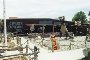
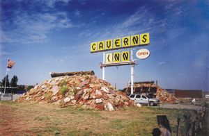
The highway sign at the parking lot entrance promised these motorists “one of Arizona’s natural wonders, 21 stories below the earth’s surface,” along with a motel, gas station, restaurant, and, of course, a curio shop.
The motel and convenience store are located along the highway, while the caverns, restaurant, and curio shop are about a mile down a back road from the main lodge. Neal House, the General Manager of Grand Canyon Caverns arranged a ride on the shuttle for me, and soon I was at the quaint little restaurant and gift shop that sit atop the caverns.
The caverns offer three different guided tours. I opted for the $9.95 standard 45-minute tour. They also offer a “Flashlight Tour,” where you can experience conditions similar to what the first visitors enjoyed, and a two-hour tour for spelunkers where tourists with a more adventurous spirit the can crawl around some of the extended and narrower passages. My guide on the tour was Brian Anderson, a long time denizen of Arizona who has been guiding at the Caverns for many years.
 The caverns were discovered in 1927 by young woodcutter named Walter Peck. He was walking through the desert one evening to a poker game when he nearly stumbled into a hole, recently made wider by torrential rains that had just washed over the area. Intrigued, he poked around a bit, but the poker game awaited and he couldn’t be late. He told the boys at the game about the big hole that had opened on the trail and, thinking they might find gold down below, they decided to go back the next day. With a lot of rope and a coal oil lantern, Walter tied a rope around himself and had his friends lower him down into the hole. By the time he reached the bottom of what is now called “Chapel of the Ages,” his friends had played out 150 feet of rope. Poking around a bit, he discovered the remains of two mummified Indians, a saddle, and what he thought was a rich vein of gold. After three excited tugs of the rope he was hauled up to the surface, where he showed the rock samples to his friends. The caverns were discovered in 1927 by young woodcutter named Walter Peck. He was walking through the desert one evening to a poker game when he nearly stumbled into a hole, recently made wider by torrential rains that had just washed over the area. Intrigued, he poked around a bit, but the poker game awaited and he couldn’t be late. He told the boys at the game about the big hole that had opened on the trail and, thinking they might find gold down below, they decided to go back the next day. With a lot of rope and a coal oil lantern, Walter tied a rope around himself and had his friends lower him down into the hole. By the time he reached the bottom of what is now called “Chapel of the Ages,” his friends had played out 150 feet of rope. Poking around a bit, he discovered the remains of two mummified Indians, a saddle, and what he thought was a rich vein of gold. After three excited tugs of the rope he was hauled up to the surface, where he showed the rock samples to his friends.
Further exploration revealed there were two main caverns. The first was the aforementioned Chapel of the Ages, measuring 130 yards long. This was connected to another, much larger cavern called “Snowball Palace” because of the globular crystals of Selenite that had formed on the cavern walls millions of years ago. Unfortunately for Mr. Peck, the “gold” turned out to be nothing more than oxides of iron in the Selenite crystals. Unfortunately, Walter had already sunk his life savings into securing the land and filing the claims, so he now needed another way to recoup his investment. He hit upon the idea of cavern tours, and soon another Route 66 attraction was luring travelers off the highway for a subterranean excursion.
Early visitors to the Caverns had to be considerably more intrepid than we are today. For 25 cents, Walter and his helpers would tie a rope around a visitor’s waist and lower them down the hole, armed only with a coal lantern and a picnic lunch. This spectacle became known as a “Dope on a rope.” Once at the bottom of the Caverns, visitors had as much time as their light would last to explore, on their own and unaccompanied, throughout the complex. Getting lost was a real danger in the dim light, but the greater danger was having one’s light go out. The guides say that after 45 minutes in the absolute darkness, your senses get confused and extreme vertigo can set in. There are no records of how many visitors had to be rescued, but luckily, we know nobody ever died.
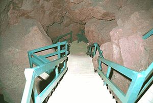
In 1936 engineers from the Hoover Dam project came to the caverns and built a series of ladders and bridges to facilitate a more civilized access. Walter promptly raised the price to 50 cents, and made visitors bring their own lanterns. The ladders required visitors to walk down — and back up — the equivalent of fifteen stories. The original 104-foot long wooden bridge is one of the stops on the tour today, and despite its many years in the caverns, it looks absolutely new. In fact, everything in the caverns remains in a pristine condition. Brian explained that the caverns remain at a constant 56 degrees and 10 percent humidity. The caves are sterile and nothing, not even lichen or mold, grows.
Some years after the Caverns were opened to tourists, the mystery of the two mummified Indian bodies was solved. Members of the nearby Hualapai tribe (pronounced WALL-a-pie) told Walter that during the winter of 1917 a particularly cold snap hit the area. Two braves had died while scouting the area and, since the ground was frozen, they were buried part way down the hole of the entrance. A deal was eventually brokered with the Hualapai that recognized the sanctity of this burial site, and the mummies were reburied at that spot. This forever sealed the natural entrance to the cave. Access to the caverns is now accomplished via one of Mr. Otis’s electric elevators, which became operational after a 210-foot shaft was blasted out of the solid rock. By the way, just in case the power goes out, a stairwell stands next to the elevator, and it is used regularly!

One of the more unexpected surprises on the cavern tour is manmade. During the 1962 Cuban Missile Crisis the U.S. Government took control of all the caves and caverns in the country. They figured these subterranean hideaways would make great bomb shelters. The bomb shelter experts estimated that Grand Canyon Caverns would hold approximately 2,000 people for two weeks. Accordingly, they stocked the larger cavern with sufficient food, water, and portable toilets for that number. For some reason, however, these same experts figured 2,000 people could get by with just three, that’s right, three rolls of toilet paper. Luckily for all of us, the crisis was diffused and the caverns weren’t needed. The supplies weren’t needed either, so they remain, all these years later, just as they were stacked (for all you lovers of C and K rations, I’ll bet there’s a tin of peanut butter that would bring back all sorts of memories). Like everything else in the caverns, guides assure us the rations are preserved, and as palatable today as they ever were.
One of the most startling moments on the tour came when Brian turned off the lights, allowing us to experience the absolute darkness of the caverns. With all lights out there is not one photon of light. It is easy to see how confusing and terrifying it would have been to be down here alone and have your lantern run out of fuel. You can literally hold your hand in front of your face and not see a thing! Then Brian lit a match; it was amazing how much light even one small flame can provide.
Exploration of the caverns continues to this day. For years, one of the most puzzling questions was where the fresh air came from. In the 1950s, engineers went to the bottom of Snowball Cavern, where they sensed airflow, and set off a case of red smoke flares. The smoke quickly dissipated into the rubble, and for days they searched the surrounding area for signs of the smoke, to no avail. Eventually they gave up, but were surprised several weeks later to here from rangers at the Grand Canyon, who reported red smoke seeping from the rocks in the canyon wall near Havasupai. What is really astounding is that Havasupai is 63 miles from the caverns!

Additionally, researchers conducting seismic tests inside the caverns have discovered four additional caverns below the originals, one below the other. Each succeeding chamber is bigger than the one above, and the bottom cavern, a full 1,500 feet below the surface, has a lake in it! The owners of the caverns are pondering an effort to open the next lower cave, if they determine it has significant interest and value.
After the tour, an effortless elevator ride whisked our group back to the surface, and — in the finest Route 66 marketing tradition — deposited us back in the curio shop.
The caverns aren’t the only draw that have helped this Route 66 attraction survive the advent of Interstates. The complex is the nearest “civilization” to the Hualapai Hilltop parking lot, 60 road miles north. This is the trailhead for the 9-mile hike into the Grand Canyon’s Havasupai Indian Reservation, and the spectacular blue-green waters and fall of Havasu Creek. For this reason the motel is surprisingly busy, so make advance reservations if you plan to spend the night. The Caverns Inn is a 48-unit motel located right off Historic Route 66. All rooms are ground level, offering easy access to your airplane. The staff will cheerfully shuttle you to the restaurant and caverns as needed.
The Caverns Inn is also the starting point for other activities in the area, including “Ranch Days,” cookouts, camping, tours, Colorado River rafting, and horseback rides, all of which can be arranged with the neighboring Hualapai Indian tribe. Also ask about a trip to Diamond Creek, where you can picnic on the banks of the Colorado River inside the Grand Canyon. Teddy Roosevelt opened the Diamond Creek road in 1912, and it is still the only vehicle access to the Colorado River in the canyon. Contact the Grand Canyon Caverns and Inn at 928-422-3223 or 928-422-3224 for more information and reservations, or visit their web site at www.gccaverns.com.
Are the Grand Canyon Caverns just another cheesy roadside attraction? Well, maybe just a little. However, in my mind they represent all of the things that made Route 66 the “Mother Road” of the country. The caverns are interesting and fun, and an easy way for aviators to rediscover the magic of Historic Route 66.
Mark Swint is a senior captain for United airlines, flying 767 and 757 aircraft based in LAX. For fun, he flies his Cessna C-185 and Beech Baron B-55. Mark is also a licensed A&P, and has just finished restoring a 1946 Aeronca 7AC. Mark has been a writer for many years, including a two-year stint in Hollywood and London working in the screenwriting business.
|
|
The Grand Canyon Caverns airport (L37) is on the Phoenix Sectional, located 18 sm on the 098 degree radial from the Peach Springs VOR (PGS - 112.0), or 36 sm on the 051 degree radial from the Kingman VOR (ING – 108.8). GPS coordinates are N35.31.5 W113.14.5. The 5100 foot runway, 5-23, is located next to the highway, and has been recently graded and is in very good shape. Though dirt, it is safe for most types of planes, and has a good, clear approach path from either direction to runway. Field elevation is 5,386 feet, CTAF is 122.8. A tiedown is available near the Caverns Inn office. The nearest fuel is either Kingman to the southwest, or Williams and Valle to the east. Be aware of the Grand Canyon Special Flight Rules Area to the north; minimum altitude in the Diamond Creek Sector is 8999 feet MSL.
|
Click here to return to the beginning of this article.  |
|