|
|
 |
| SW Aviator Magazine is available in print free at FBOs and aviation-related businesses throughout the Southwest or by subscription. |

|
 |

|
 |
 |
 |
|
The web's most comprehensive database of Southwest area aviation events.
|

|
 |

|
 |
|
Featured Site:
|
|
|
 |
|
A continuosly changing collection of links to our favorite aviation related web sites.
|

|
 |

|
 |
 |
|

|
Bryce Canyon National Park
|
|
Fly and Explore... The $100 Hike
|
 By Dave Simeur By Dave Simeur
The world is envious of the pilot’s point of view. Developed far above, pilots think in knots, and miles per minute. We share the skies with strangers who are brethren, each day spent in multiple time zones. Our experience as pilots is strange and exciting to our neighbors. Our world is much smaller, more within reach. On a personal level, the journey becomes even more surreal when backcountry exploration is the destination. Imagine leaving home, crossing 700 driving miles in 3 hours, to arrive at the bottom of a canyon where water, wind, and birds are the only sounds. Planning such an excursion can take some effort, and we all know that life can get in the way of the best intentions. To make this and other trips easier, the crew of N1234K (that is the real tail number) is planning regular trip reports to some of the best destinations in the Southwest. This report will help break down some of the logistics to have some cheap (relatively cheap), safe, family fun.
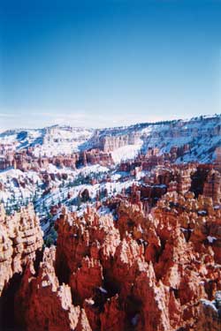
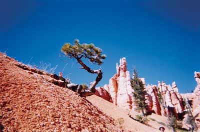
Bryce Canyon National Park, located in Southern Utah, is one of the best fly and hike destinations in the Southwest. It was named after the Mormon pioneer Ebenezer Bryce. The small, 36,000-acre park receives nearly 900,000 visitors a year without feeling crowded. Erosion has created a maze of pinnacles, spires, and slot canyons out of Claron sandstone, limestone, and mudstone. These natural amphitheaters, collectively called “Hoodoos,” are carved into the side of Paunsaugunt Plateau. Even today, the erosion slowly continues to change the appearance of the Park. As the day progresses, the colorful rock formations change through a rainbow of colors. The air is crisp and clean, allowing panoramic views of nearly 200 miles. The Ponderosa pines, grassy meadows, Piñon pines, and Fir stands are filled with wildlife. The night sky is full of stars, a perfect place to stargaze. People have lived in the rugged landscape for over 10,000 years. From early man to today’s visitors, all appreciate the beauty of the Park’s natural wonder.
Bryce Canyon Airport (elevation 7,586’) is located just northeast of the National Park. It is only minutes from lodging, restaurants, and the National Park. Weather days are best in the mountains when stable high-pressure systems prevail. Plan the flight for early hours to avoid thermals. With high density-altitudes, good performance planning is essential. Fly friendly, approach the Park from the East, and keep track of power settings in an effort to reduce noise. Plan to enter left traffic for runway 21 (length 7,400’) from the south, or over fly the airport for the forty-five degree entry to left traffic for runway 03. Navigate this area with the Las Vegas sectional. Keep in mind Helicopter, Biplane, and Cessna air tour operators work in the region, so be sure to make traffic calls.
The FBO is owned and operated by Garfield County, call 435-834-5239 for the latest information. Upon arrival, Greg Pollock or Darron Mathews will greet you. Ambassadors of the airport, the service is second to none. They provide fuel, tie downs, weather, and a pilots lounge. Rental cars are available from MS Aero Service. The FBO building is a lodge pole pine structure surrounded by a deck. The best amenities of the airport are deck chairs arranged to face Aquarius peak. Aquarius Peak is the stunning high ground to the Southeast, marking the geologic plate that defines the area.
Take care to hydrate before starting this journey. The airport and Park are between 7000 & 9000 feet MSL. Drink plenty of fluids on the way to Park and plan a pit stop along the way. Pilots often try to limit stops, and thus fail to adequately hydrate – not a good plan for a fly and hike adventure. Of course, a flight plan is an essential piece of survival gear when flying in the region. Don’t worry about poor FSS reception upon arrival; Cedar City Radio is loud and clear. When flying over southwest Utah, we suggest carrying a survival kit with plenty of water. For single-engine pilots, only small deviations are required to avoid the most rugged terrain and keep landing options open.
Bryce Canyon National Park is open all year, with a wide range of activities from Nordic skiing to horseback riding, and of course, hiking. Peak season is April through October. Ruby’s Inn will come to the airport to collect you for lunch or an overnight stay (rubysinn.com, 866-866-6616). A fixture in the area, Ruby’s offers all sorts of activities. Across the street from the main lodge you will find a rock garden, western town, horse stables, rodeo corral, and shopping. Guests have the option to stay in suites, standard rooms, cabins, or even a Teepee! The Park shuttle stops at the Inn, so no car is required between April and October. Prior to departure, call to make sure that the Park Service’s shuttle bus is in operation. Park information is available at nps.gov/brca.
National Park hiking is best started at the visitor’s centers, where rangers provide the latest trail information. We made our trip in late March, hiking in shorts through scattered snow pack. The breeze kept us nice and cool as we navigated through the famous Bryce Canyon Hoodoos. The vivid colors and geology of the park defy reason or explanation. It is one the few places that walking a trail out and back offers different scenery each way! The wide variety of trails offer visitors the option for short day hikes, longer jaunts, or several days of backcountry expedition. Queens Garden Trail is heavily populated, but worth the visit, and a great introduction to the park. The Rim trail is the best way to see the park without heavy exertion. Bryce Canyon trails are steep, we recommend using walking sticks (two legs bad, four legs good).

We chose to descend to the floor of the canyon to explore the Navajo Trail. The Navajo Trail is a loop, listed as very strenuous, that connects some of the best views and geology the canyon has to offer. We stopped at the bottom to reflect on our good fortune, great company, and enjoy a fruit snack. Frequent stops make high altitude hiking much more enjoyable. Remember to leave no trace of your passing, collect all trash, and damage nothing. Once we had finished our exploration, three mule deer greeted us in a clearing, quietly grazing. They reminded us of our next priority, dinner.
We departed the canyon and headed back to Ruby’s for a great “cowboy” steak. The family owned and operated inn provided great food and great service. When selecting from the menu, think like a pioneer (remember, when in Rome…). The steaks and chicken prepared ranch style were great. They helped us to recover our energy in expectation of our flight home the next day. The Ruby Staff treated us like family, which is why the resort is so popular.
Bryce Canyon also offers an “in the Park” that is listed on the National Historic Register. Bryce Canyon Lodge has been completely renovated to its 1920s form. The main lodge offers formal dinning in a rustic setting (lodging and dining reservations suggested months in advance). The lodge is close to the Rim Trail and other Park amenities and attractions (brycecanyonlodge.com, 888-297-2757). The lodge provides courtesy transportation to and from the Bryce Canyon airport for overnight guests.
The next day, before our departure, we toured the western part of the range by car, stopping to see the natural bridge and learn more about the geology. On the way back to the airport, we enjoyed the clear morning air. The Mooney M20E was waiting to take us home, full of fuel, and ready to go. We saluted another visitor on the way in as we made a left downwind departure, the flight home a perfect conclusion to a great weekend.
Dave Simeur flies helicopters and Citation jets out of Santa Teresa, New Mexico. He enjoys exploring the Southwest in his Mooney M20E with Wendy, his wife and co-pilot. He is a flight instructor with Momentum Interactive Aviation, specializing in ground schools and instructor support software. You can see his software and contact him at www.Momentum-i.com.
|
|
|
|
 |
SW Aviator Magazine • 3909 Central NE • Albuquerque, NM 87108
Phone: 505.256.7031 • Fax: 505.256.3172 • e-mail: publisher@swaviator.com
|
|
©2001 Southwest Regional Publishing, Inc.
|
|
|
| The material in this publication is for advisory information only and should not be relied upon for navigation, maintenance or flight techniques. SW Regional Publications and the staff neither assume any responsibility for the accuracy of this publication's content nor any liability arising fom it. |
|